Mt Bulga is only around 10 Km from Orange, so a good one to get to early for some S2S contacts coming up at 9:30am.
From Orange headed East getting onto Ophir Road, then Banjo Patterson Way. As Banjo Patterson Way heads North and becomes Lower Lewis Ponds Road there is a dirt lane on the right, took this road. Mt Bulga on the left.
Another dirt road comes off onto the left, unnamed, heading for the mountain.
The road runs along the edge of the pine forest. This road bends around to the right across the summit, there is a sign here for Mt Bulga Reserve and a rough 4WD track up to the summit behind it. Parked opposite the sign and started walking, around 300 m from the summit.
The road up could be done in a good 4WD. There were some nasty rocky bits.
Got steeper and looked interesting to try driving up...
Eventually became just a walking track up to the summit.
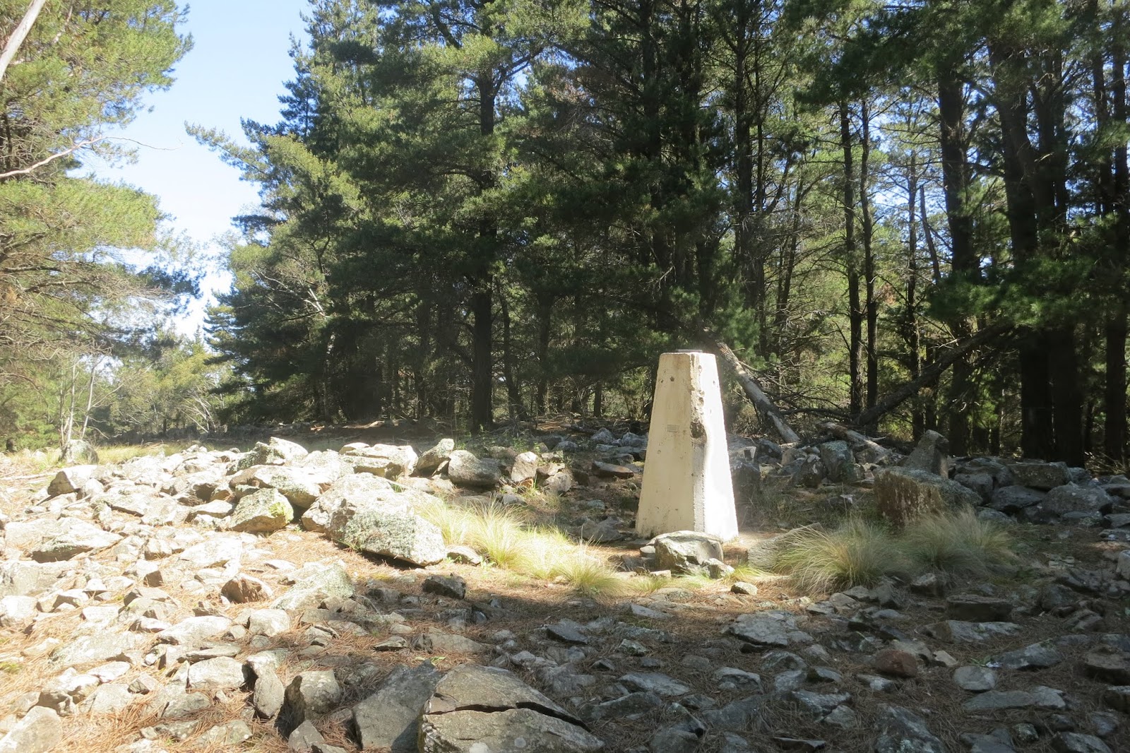
At the top saw the trig, hiding in the trees.
Nameplate on trig. Interestingly not "Bulga" but "Ophir"
Trees too close to use the trig for the squid pole. The track continued past the trig, set up the squid pole and dipole on a stump on the side of the track just near the trig.
Looking back along the track the other way
Set up the operating spot on the tarp.
Sitting on the tarp noticed this spot was buzzing with mosquitos :( Swatted some and continued on. Must put repellent in the pack in future. Started with an S2S with Andrew, VK1NAM on VK1/AC-043, Mt Stromlo, with a good signal. Worked several of the regular chasers from VK1, VK2 and VK3 with good signals. Another S2S with Simon, VK1FAAS calling me from VK1/AC-002 Mt Gingera. Well done Simon, a long walk for a 10 point summit. He had a good strong signal.
Tried 20 m. Worked Ian VK5CZ, Mike VK6MB, Nev VK5WG and David VK4DD. As the mosquitos were driving me mad packed up and headed down.
Track log of drive/walk
A blog about Amateur Radio callsign VK1DI Ian's activities on the Amateur Radio bands, mostly Summits On the Air (SOTA) and World Wide Flora and Fauna (WWFF) portable activities.
Monday, 6 October 2014
Sunday, 5 October 2014
SOTA Mt Canobolas
After activating Mt Macquarie VK2/CT-011, got an SMS from Matt VK1MA that Rod, VK2TWR would wait for me for an S2S on my next summit, Mt Canobolas, so the trip there was rather rushed...
Drove back to Carcoar, then on to Blayney, Orange and the road to Mt Canobolas. The road up starts sealed but turns to dirt, however suitable for 2WD, in fact gets lots of tourists. Near the top gets twisty and narrow, needed to watch out for oncoming cars on the bends. Reached the car park at the top, a short walk down and up the hill and ready to activate.
A problem finding an operating position, the trig was in the middle of a car park island with tourists swarming all over it...
Headed down the slope, as needed to get on air quickly, used a small gum tree for support.
Just tied the dipole legs to rocks and quickly got on air. Got on 40m, found Rod VK2TWR and Matt VK1MA chatting away wondering when I was getting on air...After waiting for them to finish called Rod VK2TWR/p for a S2S on VK2/SM-043 with a good S8 signal, despite my dodgy setup...
After working Rod chasers started calling me, told them to wait while I secured the dipole a bit better, running the legs out to a copper log and a tree branch. Some wind but more stable
Shack at the base of the tree
Got mobbed by chasers, many calling at once with strong signals. Some nice signals, VK4BZ from Brisbane a good S8. After 40 m died down went to 20 m. Lots of strong EU stations in the Oceana DX contest, but no replies to my calls. As needed to drive back to Orange and check in to accommodation did not stay long, packed up and headed down.
Drove back to Carcoar, then on to Blayney, Orange and the road to Mt Canobolas. The road up starts sealed but turns to dirt, however suitable for 2WD, in fact gets lots of tourists. Near the top gets twisty and narrow, needed to watch out for oncoming cars on the bends. Reached the car park at the top, a short walk down and up the hill and ready to activate.
A problem finding an operating position, the trig was in the middle of a car park island with tourists swarming all over it...
Headed down the slope, as needed to get on air quickly, used a small gum tree for support.
Just tied the dipole legs to rocks and quickly got on air. Got on 40m, found Rod VK2TWR and Matt VK1MA chatting away wondering when I was getting on air...After waiting for them to finish called Rod VK2TWR/p for a S2S on VK2/SM-043 with a good S8 signal, despite my dodgy setup...
After working Rod chasers started calling me, told them to wait while I secured the dipole a bit better, running the legs out to a copper log and a tree branch. Some wind but more stable
Shack at the base of the tree
Got mobbed by chasers, many calling at once with strong signals. Some nice signals, VK4BZ from Brisbane a good S8. After 40 m died down went to 20 m. Lots of strong EU stations in the Oceana DX contest, but no replies to my calls. As needed to drive back to Orange and check in to accommodation did not stay long, packed up and headed down.
SOTA Mt Macquarie
This was the first summit for me in the Central Tablelands region, Mt Macquarie VK2/CT-011.
Driving from Cowra to Blayney turned off at Carcoar and onto Mount Macquarie Road. Soon turned to dirt. Summit towers visible on a pine tree covered hill.
Turned off at a logging track on the left
After a short drive saw on the left the track up to the summit Looked steep and rough... As only 600 m parked and walked from here.
Glad I didn't drive, looked rather cut up and boggy...
Reached the top. Comms towers on the left
The trig on the right
Name plate on trig "Macquarie"
Set up the squid pole on an old stump and strung out the 40 m dipole to a couple of pine trees.
Shack on a tarp on the grass in front of the stump
Got on 40 m. Sounded quiet, hardly any signals. Livened up after calling CQ :) Mobbed by VK1, VK2, VK3 and VK5 chasers, many with S9+ signals. Tried 20 m later, only 1 chaser, Nigel VK5NIG with a good S9 signal. Oceanea DX contest on so probably being drowned out by contesters. Got an SMS from Matt, VK1MA wanting a contact so returned to 40 m and worked him.
Headed back down. As is the way got a notification that Rod VK2TWR was on a summit. Matt advised me via SMS he would wait for me on my next summit, Mt Canobolas, so hurried off to drive there.
Track log of drive/walk
Driving from Cowra to Blayney turned off at Carcoar and onto Mount Macquarie Road. Soon turned to dirt. Summit towers visible on a pine tree covered hill.
Turned off at a logging track on the left
After a short drive saw on the left the track up to the summit Looked steep and rough... As only 600 m parked and walked from here.
Glad I didn't drive, looked rather cut up and boggy...
Reached the top. Comms towers on the left
The trig on the right
Name plate on trig "Macquarie"
Set up the squid pole on an old stump and strung out the 40 m dipole to a couple of pine trees.
Shack on a tarp on the grass in front of the stump
Got on 40 m. Sounded quiet, hardly any signals. Livened up after calling CQ :) Mobbed by VK1, VK2, VK3 and VK5 chasers, many with S9+ signals. Tried 20 m later, only 1 chaser, Nigel VK5NIG with a good S9 signal. Oceanea DX contest on so probably being drowned out by contesters. Got an SMS from Matt, VK1MA wanting a contact so returned to 40 m and worked him.
Headed back down. As is the way got a notification that Rod VK2TWR was on a summit. Matt advised me via SMS he would wait for me on my next summit, Mt Canobolas, so hurried off to drive there.
Track log of drive/walk
Wednesday, 1 October 2014
SOTA Black Mountain S2S with VK7
On the 1st October a new SOTA Association, VK7, Tasmania was approved, and one of the local VK1 SOTA activators Paul VK1ATP put an alert up to activate the first summit, VK7/EC-045.
As had the day free decided to go chase him on local SOTA peak Black Mountain, VK1/AC-042. I knew it wouldn't be a strong signal at home, figured more chance on a peak, plus I get to do the first S2S to a new Association!
Black Mountain is only about a 10 minute drive from home. Parked in the lower car park as per other activations.
After a few minutes walk up the track reached the summit. Set up on the lookout platform as per my last time here, using the distance marker for a shack table.
The squid pole strapped to the metal fence and dipole legs laid out along the fence.
Got on 40 m on 7.090 and worked Paul, VK1ATP/7 on VK7/EC-045. He was about a S4R4, I was S5R5. He was mainly working VK3s.
After working him moved up to 7.095 and spotted myself to let chasers grab some points, none for me as already done this peak this year...Worked 3 VK2s, 3 VK3s and VK5BJE portable. The VK2s mentioned they were not able to copy Paul, signal too weak to work. Probably would have had problems myself at home so the quiet summit was good.
Packed up and headed home.
As had the day free decided to go chase him on local SOTA peak Black Mountain, VK1/AC-042. I knew it wouldn't be a strong signal at home, figured more chance on a peak, plus I get to do the first S2S to a new Association!
Black Mountain is only about a 10 minute drive from home. Parked in the lower car park as per other activations.
After a few minutes walk up the track reached the summit. Set up on the lookout platform as per my last time here, using the distance marker for a shack table.
The squid pole strapped to the metal fence and dipole legs laid out along the fence.
Got on 40 m on 7.090 and worked Paul, VK1ATP/7 on VK7/EC-045. He was about a S4R4, I was S5R5. He was mainly working VK3s.
After working him moved up to 7.095 and spotted myself to let chasers grab some points, none for me as already done this peak this year...Worked 3 VK2s, 3 VK3s and VK5BJE portable. The VK2s mentioned they were not able to copy Paul, signal too weak to work. Probably would have had problems myself at home so the quiet summit was good.
Packed up and headed home.
Saturday, 27 September 2014
SOTA Baldy Range VK2/ST-008
With the SOTA winter bonus season ending soon had a look at other close by summits that can claim the points. Baldy Range, VK2/ST-008 is an 8 pointer and is not too far from home, so gave it a go.
You can access it via the Baldy Range fire trail 2 ways, via Two Sticks Road or Doctors Flat Road. Doctors Flat Road looked the best option with only a couple of Km of rough road to the summit.
Drove down Uriarra Road to Urriara Crossing, turned right onto Fairlight Road, then left onto Mountain Creek Road. A short distance along Mountain Creek Road reached Doctors Flat Road on the right.
Note this is a private road that crosses several properties. There was an old sign nearby advising to shut the gates.
Drove through to the next gate, leaving the first property.
Saw a sign further along asking to contact the owner before entering. Rang the number and spoke to the owner, he agreed to let me proceed. The property is called "Little Swamp"
After passing through the property reached Brindabella National Park, then another property gate, "Dingo Dell Valley".
The sign indicated okay to continue as long as the gates left shut. After clearing the property entered Brindabella National Park again. Got to the Baldy Range Trail intersection on the left.
Note the track isn't marked, but Maginot Fire Trail on the right is, so had the correct road. A short distance up the hill reached an old alignment of Doctors Flat Road and a sign for Baldy Range Track.
The road climbs fairly steeply after this around the side of a small hill, with a few mounds and puddles to cross, but nothing that an AWD couldn't handle. My Nissan Xtrail went fine without needing 4WD, just needed a bit of clearance. The road got better once on the top of the range. Around 800 m from the summit parked on the side of the track and walked.
The road passes close to the summit, in fact enters the activation zone. Headed off into the scrub. Unlike the thick scrub of Dingi Dingi Ridge quite open and easy walking.
Near the top of the summit found a nice open grassy area with a log. Used this for squid pole support and set up the 40/20 m linked dipole here.
Set up the radio on my pack and sat on the log.
Got on 40 m. Conditions quite good with strong signals from VK1, VK2 and VK3. Worked S2S with Andrew, VK2MWP on VK2/SC-040, and Mark VK1EM on VK1/AC-027.
Saw a spot for Simon, VK1FAAS on VK1/AC-038 Tuggeranong Hill on 2 m FM. I could hear him okay but he could not hear me. Even Matt, VK1MA whom I was copying S9+ couldn't contact him. Only Andrew VK1NAM could work him. Seems he had HT radio desense problems...
Worked him okay on 40 m. Another S2S with Ian, VK5CZ on VK5/NE-102, quite weak.
Changed the links to 20 m. Got Andrew, VK1NAM locally with a good signal. After finishing with Andrew got blasted by Paul, VK5PAS with a very strong S9+ signal! Went on to work VK8GM, VK5WG, VK6MB, VK5IS, VK1DR and VK1MA.
Another view of the shack.
Had lunch, packed up and went home.
You can access it via the Baldy Range fire trail 2 ways, via Two Sticks Road or Doctors Flat Road. Doctors Flat Road looked the best option with only a couple of Km of rough road to the summit.
Drove down Uriarra Road to Urriara Crossing, turned right onto Fairlight Road, then left onto Mountain Creek Road. A short distance along Mountain Creek Road reached Doctors Flat Road on the right.
Note this is a private road that crosses several properties. There was an old sign nearby advising to shut the gates.
Drove through to the next gate, leaving the first property.
Saw a sign further along asking to contact the owner before entering. Rang the number and spoke to the owner, he agreed to let me proceed. The property is called "Little Swamp"
After passing through the property reached Brindabella National Park, then another property gate, "Dingo Dell Valley".
The sign indicated okay to continue as long as the gates left shut. After clearing the property entered Brindabella National Park again. Got to the Baldy Range Trail intersection on the left.
Note the track isn't marked, but Maginot Fire Trail on the right is, so had the correct road. A short distance up the hill reached an old alignment of Doctors Flat Road and a sign for Baldy Range Track.
The road climbs fairly steeply after this around the side of a small hill, with a few mounds and puddles to cross, but nothing that an AWD couldn't handle. My Nissan Xtrail went fine without needing 4WD, just needed a bit of clearance. The road got better once on the top of the range. Around 800 m from the summit parked on the side of the track and walked.
The road passes close to the summit, in fact enters the activation zone. Headed off into the scrub. Unlike the thick scrub of Dingi Dingi Ridge quite open and easy walking.
Near the top of the summit found a nice open grassy area with a log. Used this for squid pole support and set up the 40/20 m linked dipole here.
Set up the radio on my pack and sat on the log.
Got on 40 m. Conditions quite good with strong signals from VK1, VK2 and VK3. Worked S2S with Andrew, VK2MWP on VK2/SC-040, and Mark VK1EM on VK1/AC-027.
Saw a spot for Simon, VK1FAAS on VK1/AC-038 Tuggeranong Hill on 2 m FM. I could hear him okay but he could not hear me. Even Matt, VK1MA whom I was copying S9+ couldn't contact him. Only Andrew VK1NAM could work him. Seems he had HT radio desense problems...
Worked him okay on 40 m. Another S2S with Ian, VK5CZ on VK5/NE-102, quite weak.
Changed the links to 20 m. Got Andrew, VK1NAM locally with a good signal. After finishing with Andrew got blasted by Paul, VK5PAS with a very strong S9+ signal! Went on to work VK8GM, VK5WG, VK6MB, VK5IS, VK1DR and VK1MA.
Another view of the shack.
Had lunch, packed up and went home.
Sunday, 21 September 2014
SOTA activation Dingi Dingi Ridge
Dingi Dingi Ridge VK2/ST-004 is a high point within Brindabella National Park, just to the Northwest of Canberra. At over 1300 m it is worth 8 points, with 3 more for winter bonus points, so decided time to activate it before the winter bonus season ends.
To get there, took the Brindabella Road, turned off onto Blue Range Road, headed along this, entering Brindabella National Park.
Continued along Blue Range Road until it joined Two Sticks Road. Two Sticks Road runs around the side of Devils Peak, VK2/ST-003. There was a turn off this on the right onto Baldy Range Trail. Note the sign for Baldy Range Trail has been destroyed...After a short section of Baldy Range Trail took the track on the left, Dingi Ridge Trail.
The roads up until now are probably okay for a 2WD in the dry, however you probably need at least an AWD or 4WD for Dingi Dingi Ridge Trail. My Nissan Xtrail went okay, mainly need clearance as some tricky rocky bits and spoon drains. Followed Dingi Ridge track until the closest point to the summit, parked here off the road.
Entered into the bush on the left. This was probably not the best approach as fairly thick scrub here...
Lots of wattle regrowth. Thankfully did thin out as I got higher. From reviewing VK1NAM Andrew's track log might have been better to follow the road a bit further on before bush bashing up. Once on the top ridge not too bad. View from a minor saddle before the final summit.
Reached the activation zone. Looking for a suitable clearing for antennas found a nice grassy clearing on the Southern side, looking towards Mt Coree, VK1/AC-023
Set up the squid pole on a small sapling, able to lay out the 40 m dipole okay. Operated on a tarp on the grass. The sun came out at last.
Looking across the clearing
Some views of parts of Canberra through the trees.
Got on 40 m, started with a S2S with Russ, VK2BJP on VK2/RI-035, One Tree Hill near Albury. Then got the usual pileup of chasers...
Had a very weak copy on Rod, VK2TWR/p on VK2/ST-032, only a R4 S1, seems he had antenna problems, others had problems copying him.
Switched to 2 m FM on the Jpole and tried a spot. Got Matt, VK1MA, 59+, always gets out well on 2 m. Also a good copy with Andrew VK1NAM, and a weak copy on Andrew VK2MJP near Queanbeyan. Andrew was on a hand held outside standing on his water tank for height!
Tried 30 m, worked 4 chasers, VK2YK, VK3XPT/p, VK1MA and VK3AFW. 30 m is a great band for around VK, just not that many using it.
Returned to 40 m after Matt VK1MA alerted me to a S2S. Worked VK2XDM/VK3EQ on VK3/VN-005. Later worked S2S with VK3YY on VK3/VT-010, and a group of activators on VK3/VC-002 Mt Donna Buang, having a SOTA BBQ lunch. VK3KIS, VK3OHM, VK3BQ and VK3PZ.
As I was packing up heard Rod, VK2TWR come up on another summit, VK2/ST-021, with a good signal, he had fixed his antenna problem.
While packing up found a small piece of tape on the ground, seems I wasn't the first to operate here :)
Headed back down. Went a bit more North, avoided a lot of thick scrub, but still very thick just near the car...You can see the squiggles in the track log as I attempted to navigate through it.
To get there, took the Brindabella Road, turned off onto Blue Range Road, headed along this, entering Brindabella National Park.
Continued along Blue Range Road until it joined Two Sticks Road. Two Sticks Road runs around the side of Devils Peak, VK2/ST-003. There was a turn off this on the right onto Baldy Range Trail. Note the sign for Baldy Range Trail has been destroyed...After a short section of Baldy Range Trail took the track on the left, Dingi Ridge Trail.
The roads up until now are probably okay for a 2WD in the dry, however you probably need at least an AWD or 4WD for Dingi Dingi Ridge Trail. My Nissan Xtrail went okay, mainly need clearance as some tricky rocky bits and spoon drains. Followed Dingi Ridge track until the closest point to the summit, parked here off the road.
Entered into the bush on the left. This was probably not the best approach as fairly thick scrub here...
Lots of wattle regrowth. Thankfully did thin out as I got higher. From reviewing VK1NAM Andrew's track log might have been better to follow the road a bit further on before bush bashing up. Once on the top ridge not too bad. View from a minor saddle before the final summit.
Reached the activation zone. Looking for a suitable clearing for antennas found a nice grassy clearing on the Southern side, looking towards Mt Coree, VK1/AC-023
Set up the squid pole on a small sapling, able to lay out the 40 m dipole okay. Operated on a tarp on the grass. The sun came out at last.
Looking across the clearing
Some views of parts of Canberra through the trees.
Got on 40 m, started with a S2S with Russ, VK2BJP on VK2/RI-035, One Tree Hill near Albury. Then got the usual pileup of chasers...
Had a very weak copy on Rod, VK2TWR/p on VK2/ST-032, only a R4 S1, seems he had antenna problems, others had problems copying him.
Switched to 2 m FM on the Jpole and tried a spot. Got Matt, VK1MA, 59+, always gets out well on 2 m. Also a good copy with Andrew VK1NAM, and a weak copy on Andrew VK2MJP near Queanbeyan. Andrew was on a hand held outside standing on his water tank for height!
Tried 30 m, worked 4 chasers, VK2YK, VK3XPT/p, VK1MA and VK3AFW. 30 m is a great band for around VK, just not that many using it.
Returned to 40 m after Matt VK1MA alerted me to a S2S. Worked VK2XDM/VK3EQ on VK3/VN-005. Later worked S2S with VK3YY on VK3/VT-010, and a group of activators on VK3/VC-002 Mt Donna Buang, having a SOTA BBQ lunch. VK3KIS, VK3OHM, VK3BQ and VK3PZ.
As I was packing up heard Rod, VK2TWR come up on another summit, VK2/ST-021, with a good signal, he had fixed his antenna problem.
While packing up found a small piece of tape on the ground, seems I wasn't the first to operate here :)
Headed back down. Went a bit more North, avoided a lot of thick scrub, but still very thick just near the car...You can see the squiggles in the track log as I attempted to navigate through it.
Friday, 19 September 2014
WWFF mapping
For the World Wide Fauna and Flora Award there was a list of qualifying parks for Australia, VKFF parks. See Paul VK5PAS's website http://www.wwffaustralia.com/
Originally this list was missing the co-ordinates for many parks, I filled in the missing co-ordinates, using Google maps searches, to produce kml files for mapping in Google Earth, eg for VK2 NSW VKFF references. Handy if you have Google Earth.
Paul recently contacted me for assistance to Mario, DL4MFM, who runs http://www.adventureradio.de/, Adventure Radio, which contains a world map of all WWFF references at http://www.qwj.de/ The database had quite out of date and just plain wrong coordinates for the VK WWFF parks. For example, Namadgi NP just South of me VKFF-377 appeared well West near Gundagai...
I emailed Mario my park co-ordinates list which he used to update the database used for mapping. Here is the result for VK
Zooming in on SE NSW. Hover the mouse over a dot and the park reference and name is displayed, eg VKFF-377 Namadgi NP
Click on a dot and there are displays of co-ordinates in different formats, handy.
Trust this mapping is of use to those planning activations of WWFF parks in VK.
Originally this list was missing the co-ordinates for many parks, I filled in the missing co-ordinates, using Google maps searches, to produce kml files for mapping in Google Earth, eg for VK2 NSW VKFF references. Handy if you have Google Earth.
Paul recently contacted me for assistance to Mario, DL4MFM, who runs http://www.adventureradio.de/, Adventure Radio, which contains a world map of all WWFF references at http://www.qwj.de/ The database had quite out of date and just plain wrong coordinates for the VK WWFF parks. For example, Namadgi NP just South of me VKFF-377 appeared well West near Gundagai...
I emailed Mario my park co-ordinates list which he used to update the database used for mapping. Here is the result for VK
Zooming in on SE NSW. Hover the mouse over a dot and the park reference and name is displayed, eg VKFF-377 Namadgi NP
Click on a dot and there are displays of co-ordinates in different formats, handy.
Trust this mapping is of use to those planning activations of WWFF parks in VK.
Subscribe to:
Posts (Atom)