Thursday, 16 October 2014

SOTA North Brother VK2/MN-081

After activating Mt Yarrahapinni drove to Kempsey for lunch, then turned off to Port Macquarie and followed the coast South to Laurieton, at the base of North Brother.

North Brother is one of 3 "brother" mountains, named by Captain James Cook on his discovery voyage of the East Coast of Australia in 1770 since they resembled each other. Amazingly the aboriginals also knew these as the 3 Brothers, in the dreamtime, 3 brothers were killed by a witch and buried under the mountains, the youngest one being Dooragan.

Drove from Laurieton up to North Brother lookout in Dooragan National Park.


A terrific lookout here over the town of Laurieton, looking South to Port Macquarie.


The site is used by hang gliders to launch from. Saw some flying later down in Laurieton.


On the South side of the car park another lookout, Don Johnstone Lookout. The mountain on the left is South Brother VK2/MN-078 at 494 m and the one on the right is Middle Brother VK2/MN-066 at 558 m.


Just to the East of this lookout the track to the top of North Brother starts


A bit overgrown but still easy walking.


Reached the North Brother trig


Nameplate on the trig, "Camden Haven"


Set up the squid pole on the trig, dipole legs tied off to a couple of branches. A bit tricky finding a free path for the wires through the trees.


Looking the other direction


Set up the radio on the tarp. Lots of mosquito's buzzing about, luckily too small to bite me, just annoying... Got on 40 m. Worked VK4DD, VK3ZPF/P, VK2WTY and VK2IO.

Tried 30 m, worked VK3PF, VK2YW and VK5WG. Gave 40 m another try, worked VK3VTH/2.

Switched to 20 m, worked VK3XL, VK3AFW, VK5PAS and VK3DAC. Also a local station, VK2HOT Bruce in Port Macquarie with a strong signal.

Went back to 40 m, worked VK1NAM and VK1EM. As getting late in the day headed down to Laurieton to get accommodation for the night.

SOTA Mt Yarrahapinni VK2/MN-079

After Coffs Harbour continued driving South on the Pacific Highway. South of Macksville took the turnoff to Donnellyville then Albert Drive, Rosewood Road. There are signs for Yarriabini National Park.


Rosewood Road starts sealed but turns to dirt. Still okay for 2WD. Mt Yarrahapinni visible on the left.


Entered Yarriabini National Park


Reached the turnoff to Tower Road, leading to the summit


A tourist lookout below the summit


Good view of South West Rocks, and Big Smoky VK2/MN-117


Looking South to North Brother, VK2/MN-081


Continued up the road to the summit. Parked and walking into the activation zone. Lots of towers


Mt Yarrahapinni Trig


Nearby on the road a distance marker


Just near the marker set up the squid pole on an Optus cable warning sign


Set up the radio shack on the tarp


Got on 20 m. Lots of local noise from the comms towers :( Managed to work 5 chasers, VK3AFW, VK3DAC, VK5WG, VK3EHR and VK3DET. Tried 40 m, got VK2IO, VK2JDS and VK2TAM.

While there a group of 4WDs arrived, had a chat to them about SOTA.

Packed up and headed South to Kempsey for lunch.

Wednesday, 15 October 2014

SOTA Mount Coramba VK2/MN-056

After activating End Peak VK2/MN-098 returned to Buxner Park Road, headed North West, this becomes Central Bucca Road, turned off onto Mount Coramba Forest Road on the left. Sign for Mt Coramba


The road is unsealed but suitable for 2WDs. Parked below the activation zone and walked up the road to the communications towers. The road ended in a turning circle in front of the towers. Scrambled up an embankment to find the trig


I tried setting up the squid pole on the trig and running the dipole out here. There was S9+ of electrical noise on all the bands :(

Packed up and moved down to the turning circle area. Used a fence post for squid pole support, running the dipole along the road and across the turning circle.


Set up the shack in the shade of the building


Got on 20 m. Now around S8 of noise, managed to work Ron, VK3AFW, mainly because he was a strong S9... Tried 30 m, got Gerhard VK2IO, John VK2YW and Jeff VK2AGC, hard to read in the QRM. 40 m was still too noisy for use...So once again 30 m saved me from a non qualifying activation...

The flies and noise on the bands were driving me mad, packed up after qualifying and headed back to Coffs Harbour for the night.


SOTA End Peak VK2/MN-098

End Peak, SOTA ref VK2/MN-098 is located about 4 Km from the Centre of Coffs Harbour, so figured an easy one to do in the morning after a night in town.

Drove North on the Pacific Highway, past the "Big Banana" (tourist attraction) to Buxner Park Road on the left. This climbed up through the banana plantations, reached a turnoff on the left "Sealy Lookout Drive"


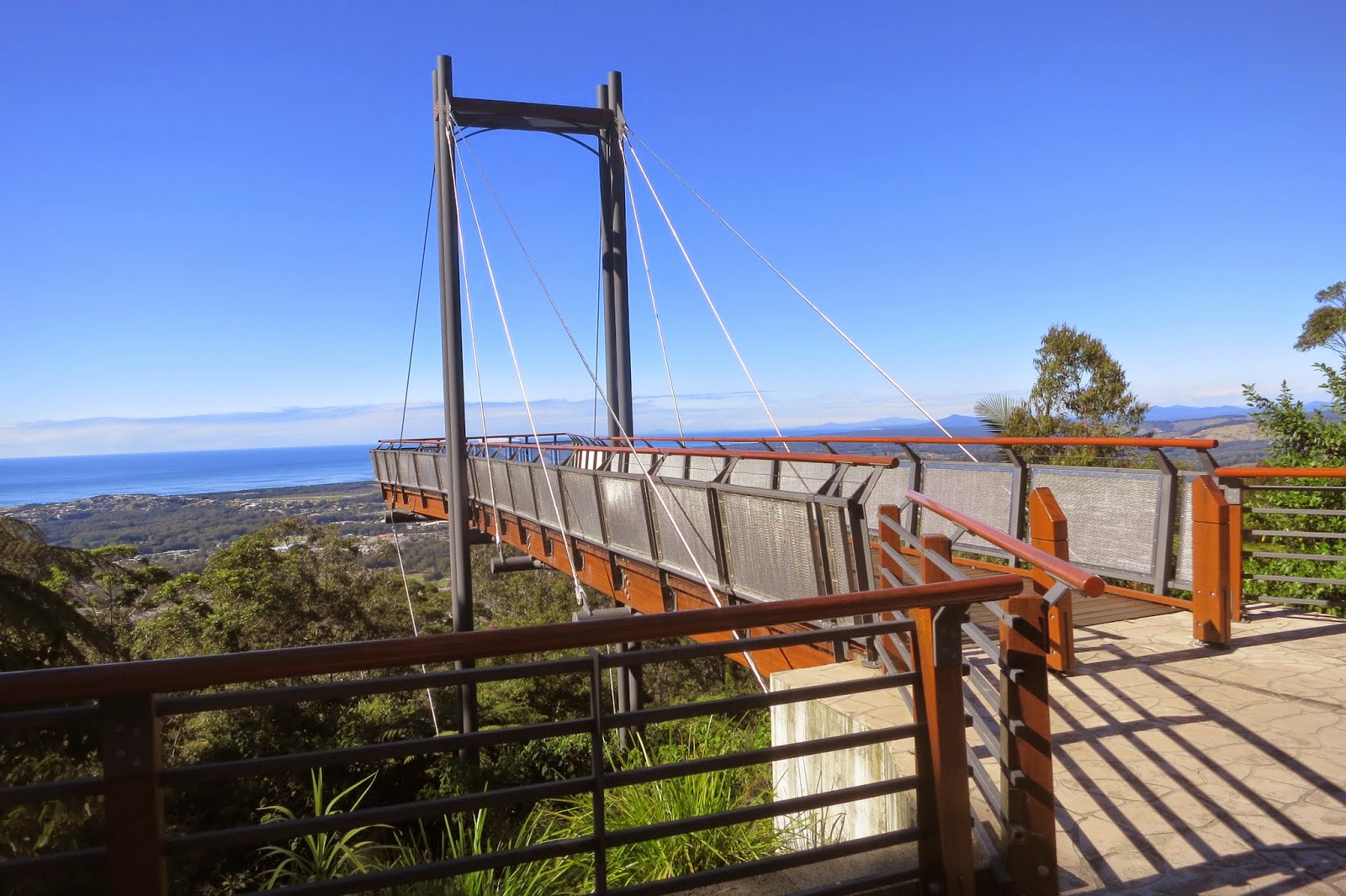
This took me past Sealy Lookout, ending at "Forest Sky Pier", a tourist lookout over Coffs Harbour


Fantastic views over the town and surrounding area. Looking due East


Looking South over the town suburbs to distant peaks.


Some signs to help identify features.


Nice as this was, this was not the SOTA summit, still 1.6 Km away. The road ended at the end of the lookout car park, and a walking track started beyond.


Just past the bollards a picnic area, then a walking track. Nice rainforest.


The track rose but didn't take me up to the summit, went down again :( There were 2 minor peaks to walk over before reaching the true SOTA summit. No trig that I could find, just a high point on the hill just off the track on the right.


The vegetation off track was quite thick with no suitable room for a dipole, so set up the squid pole and dipole on the main walking track. Had problems with the dipole legs with nearby branches but got something up.


Shack on the tarp


Got on 40 m. Made 1 contact, VK3FPSR, a low 41 signal. As I expected not much luck on 40 m QRP this far North.

Went to 20 m. My first contact was local station Paul, VK2KTT, close by in Coffs Harbour. Had a bit of a chat about the local peaks. He remarked a 4WD is needed for most of the nearby ones, which is why he hadn't done any activations yet...

Worked Nev VK5WG. No more chasers, only 3 contacts, so not qualified yet...Got a spot from Peter, VK3PF asking me to try 30 m. After some more fiddling with close by vegetation got the 30 m dipole up, worked Peter with a 43 signal, and qualified the summit. Stayed on 30 m, worked VK3DET, VK3AUU and VK2EGC/4 so 30 m helped me get this one qualified for sure.

Packed up and headed to nearby Bruxner Park for lunch, then on to Mt Coramba

Track log of walk


Track profile. Note the 2 minor hills climbed and descended to reach the summit...


Tuesday, 14 October 2014

SOTA Glenugie Peak VK2/NR-039

After activating Woodford Hill near Maclean continued heading South on the Pacific Highway, stopping for lunch at Grafton. Driving from Grafton to Coffs Harbour noticed a SOTA peak not far from the highway, Glenugie Peak, so turned off to give it a try.

Headed off along Franklins Rd, a good unsealed road, until turning off at an unmarked track that seemed to head for the summit. Map indicated it as "Lookout Road"


Seemed to get a bit rough and overgrown later so parked near this junction and started walking. Didn't look like it gets used much...


Came to a junction at the base of the summit. Left or right track? Only had a rough map on the GPS. I went right as it seemed to climb closer to the summit on the map.


After a short walk looked like it wasn't going up the summit. As fairly close now decided to just bush bash and head up the ridge to the top. Steep but not too bad, just clambered over rocks on the ridge line


Some good views out to the East


Got to the top, discovered there was a road up...seems I should have taken the left track at the fork...


There was also a rickety looking fire lookout tower


Climbed up the ladder to take a look


Didn't hang about, the floor looked like it was about to collapse, boards missing...


Looked for a suitable place for strapping a squid pole. The road going up had an odd looking tree on the side suitable for support.


Looking down the road


Looking up the road. Set up the shack on the tarp in the shade.


Got on 40 m. Worked VK2GKA, VK3ANL/2, VK3FPSR and VK2JDS mobile. Tried 20 m, worked VK3AFW, VK6MB and VK3TKK.

Packed up and headed down. Found the summit road joined the road that I had seen on the left, so could have walked on roads all the way...Although quite rough, would need a good 4WD to negotiate.

Track log of walk You can see my bush bash to the East and walk down the road on the West.